Over the past few years we’ve stretched our comfort zones to such an extent that we don’t really know where the edges are anymore! I’m pretty sure we stepped outside them this morning, though, when we boarded a bus and headed out into the Chinese countryside with no definite idea how we’d get back to Jinan!
The bus dropped us off beside the highway and we walked two kilometres into the historic village of Zhujiayu. After the noise and pollution of city life in China, a walk in the country was literally a breath of fresh air! The crops on either side of the road were heading out already but it was a bit too soon to tell for sure if they were barley or bearded wheat.
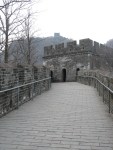
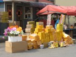
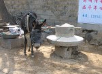
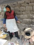
Walking the narrow stone streets of Zhujiayu is a journey back in time. Protected by hills on three sides and dating back to at least the Ming and Qing dynasties, it’s easy to see why it’s been used as a set for a number of movies and television dramas. Though the central street was crowded with vendors selling snacks and tacky tourist souvenirs, we were delighted to see that effort has been made to restore parts of the crumbling village including the wall that enclosed its northern flank and to bring history to life for those who visit. We watched a donkey grinding grain into course flour that was then sifted by hand and used to make the chive stuffed tortillas that we ate for lunch. They were cooked outdoors on a small clay oven.
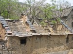
We found the construction of the now crumbling structures fascinating. Most were built of stone from the surrounding hillsides but others were made of brick covered with a layer of some kind of plaster, a building method still in use in this country today. Beneath the tiled roofs was a thick layer of thatch that would have acted as insulation.
After spending a few hours exploring almost every nook and cranny in the village, it was time to figure out how we’d get back to Jinan. According to our trusty Lonely Planet guidebook, there might be a bus that would take us to nearby Mingshui where we could catch another bus back to Jinan. If not, we could walk back to the highway and try flagging down any bus heading back toward Jinan.
As we exited the site, we stopped at the tourist services building to see if anyone there spoke enough English to advise us. Neither of the women on duty did but one of them hustled out to find someone who could. She soon returned with three smiling men. One of them spoke a few words of English but he phoned his wife who was somewhat more fluent and by passing the phone back and forth, we learned that her advice was that we walk back to the highway and flag down a bus. After the gentlemen produced their cameras and had their pictures taken with us, we headed off to do just that.
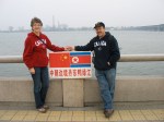
As we exited the gate, however, we were surrounded by taxi drivers offering to drive us into Mingshui or even the entire 80 km back to Jinan. Of course, they wanted an exorbitant amount in return for their services so we quickly said no and went on our way. I soon noticed that one of the men who’d crowded around us as we talked to the taxi drivers was following us on the opposite side of the road. When we got out of earshot of the others, he crossed the road and told us in broken English that if we would wait for ten minutes while he walked home and got his car, he would drive us to the bus station in Mingshui at no cost! We’ve found over and over again that the Chinese are more than willing to do things like this for us; in fact, they seem to consider it a privilege! As he drove, he explained that one of the reasons that the Chinese love Canadians is because more than fifty years ago, a Canadian doctor helped the Chinese people very much. He was, of course, speaking of Dr. Norman Bethune who died in China in 1939 while serving as a battlefield physician during the Japanese invasion of this country. He is considered a beloved hero to this day.
Though the bus from Mingshui delivered us to an unfamiliar bus station (Jinan has at least three of them) the taxi ride back to our hotel wasn’t much longer than it would have been from the main station where we caught our outgoing bus this morning. Another adventure was complete and our comfort zones, just a little bit bigger! Thank you, Dr. Bethune!
-

- img 1479
-
- img 1495
-

- img 1450 2
-
- img 1494
-
- img 1466