Tomb Sweeping Day

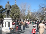
Tomorrow, April 4th, is Qingming Festival in China. Pronounced Chingming and known as Tomb Sweeping Day in English, this is a day to honour dead ancestors by travelling to the family tomb to sweep, clean and place flowers and offerings of food and drink on the grave.

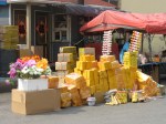
Burning paper that is meant to resemble money in hope that the deceased is not lacking anything, is also a common practice; so common, in fact, that the authorities are urging people to take precautions and not allow fires to get out of control. Apparently, across China, a total of 520 million people visited their ancestors’ tombs during last year’s festival and 200 forest fires were reported during the three day holiday!

This week, we see huge stacks of the gold coloured paper everywhere. Looking something like fancy paper napkins, it’s piled in the marketplace and outside stores waiting for people to purchase it and burn it, sometimes on the graves but not always. Paper burning was also part of the Lantern Festival that took place at the end of the Chinese New Year celebrations. That night, as fireworks exploded overhead, bonfires lined the streets outside our building and we already saw a couple of people burning a pile of the paper a couple of evenings ago on the sidewalk directly across the street from where they purchased it.

In addition to remembering dead ancestors, in modern times Qingming has also been seen as a time to pay respects to those who’ve died in incidents considered sensitive in China, incidents such as the Tiananmen Square massacre that took place in Beijing on Tomb Sweeping Day in 1976.

Qingming is celebrated on the 104th day following the Winter Solstice or the 15th day after the Spring Equinox. In addition to being a time of remembrance, it’s also a time to celebrate the coming of spring and in farming communities, it marks the time to begin plowing and seeding. Outdoor pursuits including kite flying are popular Qingming activities. Though spring seems a little late this year, the past couple of days have been the warmest since we arrived in China. The grass is finally starting to turn green and I was delighted to notice tiny buds on one of the trees we passed on our walk this afternoon.

We hope that the beautiful spring weather continues for the next few days as we’re off to Dandong for our three day Tomb Sweeping holiday. Dandong, a 4 hour bus trip north of here, is located just across the Yalu River from North Korea but more about that when we get back!

The heart of the city

We’ve spent the last couple of Sundays with students but today we were on our own so we decided to explore the heart of downtown Dalian.

In spite of the fact that Dalian is a city of some 3.4 million people, it’s quite compact and easy to get around by bus. Since almost everyone lives in an apartment and there are virtually no single family dwellings, it’s not a sprawling metropolis like a lot of North American cities are.

We started our day by catching a bus to the train station. Long-distance buses depart from various points around the station so we scouted around and figured out where the buses to a couple of the places we’re hoping to visit in the not too distant future leave from. Once we’d found what we were looking for, we set off on foot for Zhongshan Square stopping for lunch along the way.

KFC and McDonald’s are probably the most popular western fast food restaurants in Asia. They seem to be everywhere. I think the last time we ate at KFC was in December 2008 in Hanoi, Vietnam. We don’t eat at KFC in Canada and hadn’t really planned on it here either but we’d both reached the point where we were craving a meal that didn’t involve either rice or noodles and the KFC that we passed on the way to Zhongshan Square was just too unique to pass by!

Zhongshan Square (which is actually circular) is the hub of Dalian’s business district. With ten roads radiating out from its central roundabout, it is encircled by ten buildings dating from the early 1900s that have been declared cultural heritage buildings under the protection of both the Chinese government and the Dalian municipal government. Though the central part of the square is undergoing reconstruction at the moment, I was so enthralled by the classical architecture surrounding it that I hardly noticed. We walked the entire circle admiring each of the stately buildings and remarking on the contrast with the much more modern structures that formed a backdrop for them before continuing our walk north along Shanghai Road toward Russian Customs Street.

Dalian was originally a Russian seaport. In 1898, the Russian Empire leased Liaoning Peninsula from the Chinese Qing dynasty and laid out a modern city that they named Dalny. After the Russo-Japanese war in 1905, Dalny was yielded to Japan and its name became Dairen. Prior to the unconditional surrender of Japan in August of 1945, Dairen was liberated by the Soviets who once again governed the city until it was presented to the Chinese Communist government without any compensation in 1950. Dalian’s many squares with their sculptures, lawns and western-style fountains were constructed by Russian architects who were enamoured with French culture and design.

Russian Customs Street retains some of the flavour of Dalian’s Russian days but I was disappointed by the aggressiveness of the many vendors hawking Russian stacking dolls and other cheap souvenirs. I’m not sure if any of them were genuine. I did purchase a cute scarf but it was made in Taiwan!

From Russian Customs Street it was a short walk back to the train station to catch a bus back home where we’re spending a quiet evening resting our tired feet!

Sunday afternoon in Zhongshan Park

Our students are encouraged to spend time with us outside class so that they can practice using their English in a variety of different situations. One of my classes has taken this to heart and we’ve already been out for several meals and activities with some of them. Last night I taught one of the girls the expression “win-win situation” because it is exactly that. They have the opportunity to develop their language skills while we get to experience things we’d otherwise having difficulty accessing because of our lack of knowledge of the language and the culture.

Yesterday was a perfect example. We met Vicky, a native of Dalian, for lunch at a restaurant near her home and experienced spring pancakes for the first time. Spring pancakes are essentially small, thin tortillas that you wrap a variety of stir fried foods in. A little bit messy but very delicious.

Afterward, we walked to Zhongshan Park together. The focal point of the park is an old Buddhist temple. Having seen many of these in other Asian countries we could easily imagine its original splendour but unfortunately, it’s in a sad state of disrepair and people were scattered about the steps and plaza selling a variety of rather junky looking wares.

Behind the temple is what could easily be a beautiful park. Vicky was embarrassed by its unkempt appearance but I could easily imagine how much better it will look when the bare trees burst out in leaf. It was the vibrancy of the many people enjoying the park that delighted me however! Clusters of men gathered around poker games while one group played a form of checkers. Musicians playing a variety of traditional and modern instruments played in different spots throughout the park and on a wide open plaza overlooked by a bronze statue of Sun Yat-Sen, a revolutionary leader of the early 1900s who became known as the founding father of Nationalist China, people were dancing! We stopped to watch and particularly admired one very graceful couple. When the man noticed us watching, he left his partner and approached us. Extending his hand, he asked me to dance and dance I did! The steps were new to me but he was a skilled leader and I soon picked up on the routine. What fun! Richard and I love to dance so on Vicky’s urging, we took to the dance floor together when my Chinese partner returned to his lady.

Moving on, we came upon what at first appeared to be a children’s playground. Upon looking more closely, however, we realized that it was actually a collection of exercise equipment for adults. Of course, I had to try out a few pieces! We also enjoyed watching a man working out on the parallel bars. His routine made my 20+ push ups each morning look quite pathetic!

After leaving the park, we took a bus to a shopping mall where we’d arranged to meet a fellow teacher and a couple more students. We relaxed and chatted for an hour or more in a lovely coffee shop before walking to another restaurant for supper. Three more students joined us there. There were now nine of us and seated in a private room around a circular table, we enjoyed another feast and more visiting before finally making our way home.

It was definitely a winning day!

Are they or aren’t they?

It always boggles my mind that new rocks mysteriously appear in farmers’ fields each season! Though it seems as if they must simply drop from the sky, I’m told that it’s actually frost action that brings them to the surface. Today, while I was harvesting in one of the most recently cleared parts of Louis’ land, the combine picked up one of these rocks that lay hidden in a swath of canola. In addition to plugging up the machine, it broke three teeth on the pick-up auger as well as the chain that turns it.

Climbing down from the machine, I proceeded to unplug the pick-up by hand all the while wishing that I’d thought to bring a pair of work gloves with me. As the scratches on my arms will attest, canola straw is brittle and sharp. Eventually I cleared enough of it away to expose the rock wedged in underneath. As I pulled it out, what could have been nothing more than an annoying delay became something much more intriguing. Could that possibly be a ribstone in my hands?

Ribstones , carved by the natives who wandered this windswept prairie more than 1000 years ago, are thought to depict the ribs of buffalo, the animal that provided for so many of their needs. We first saw this type of rock carving at a native ceremonial site on a high point of land located about 24 km north of here. Here’s one of the rocks found there

and here’s the rock I found in the combine today.

Is it only my imagination or do you see a similarity?

While Louis went to town to buy a new chain, I picked up other rocks strewn around the area and piled them up so that they can be easily found and removed from the field before one them causes another mishap. I looked closely at each one before adding it to the pile but they were just ordinary rocks void of interesting markings of any kind. A little stone, too small to be a threat, caught my attention only because its light colour stood out against the darker field. Picking it up, I noticed immediately that it fit snugly into my palm. Examining it more closely, I realized that it appeared to have been carved into its present shape and that one edge formed a sharp blade.


It was easy to imagine a young brave chipping away at this rock turning it into a tool that his iskwew (is-KWAY-oh, Cree word for woman and the word that our term squaw is likely derived from) would use to scrape the hides after his next hunt. Perhaps it was an elderly man, one too old to join the hunt, who spent his time making tools like this one.

As you can see, hours on the combine leave plenty of time for my imagination to run wild! Are these simply unusual rocks or are they artifacts; remnants of times long past and people who roamed these parts long before the fields were cleared and cultivated? When harvest is over, I hope to do some research and try to find out and I’ll probably be back in that field picking rocks again in hopes of finding more of interest!

Barkerville

Like the miners of old, our destination as we travelled British Columbia’s gold rush trail was Barkerville situated high on the western edge of the Cariboo Mountains. Billy Barker found gold in nearby William’s Creek in 1862 triggering a stampede of thousands hoping to strike it rich. Barkerville soon had the largest population north of San Francisco and west of Chicago. Hungry for gold, men came from around the world and businesses of every description sprang into existence to provide for their needs and to profit from their earnings. Barkerville burned to the ground in September 1868 but it was quickly rebuilt.

As time went by and the gold supply dwindled, Barkerville became little more than a ghost town. In the late 1950s, the government of British Columbia decided that the town should be restored and operated as a tourist attraction. A great deal of effort went into ensuring its authenticity. Interestingly, as restoration began much was learned about life in Barkerville during its heyday from newspapers found stuffed behind walls to provide insulation from winter’s bitter cold.

When we walked through the doors of the Visitor’s Centre onto the streets of Barkerville, we stepped back in time. If you’ve been reading this blog for very long, you know that we are fascinated by old abandoned houses and the stories of the people who lived in them. Now imagine us surrounded by a whole town with more than 125 historical buildings, some original and some reconstructed! Boardwalks and dirt streets preserve the look of the original town and attendants in period costume add to the ambiance and entertain visitors with Barkerville’s stories.


Over the years, we’ve visited a number of similar sites; Fort Edmonton, Calgary’s Heritage Park, Nova Scotia’s Fortress of Louisbourg and Upper Canada Village near Morrisburg, Ontario. The latter is probably still my favourite because of its working lumber mill, textile mill and flour mill but unlike Barkerville, most of these are compilations of buildings brought from various different locations. Barkerville is unique in that it existed as a living town exactly where it stands today. The people whose stories we heard were real people. They came from around the world in search of gold and stayed to form a community. As we wandered the cemetery just outside town, we saw their names on the headstones. I wondered what it must be like for those who are still alive today who grew up in Barkerville and who saw their hometown become first a ghost town and then a tourist attraction. I wonder how many of them ever go back.

We easily spent a day and a half at Barkerville. We did the guided town tour and the historical tour of Chinatown, we took in the Cornish Waterwheel demonstration and ate at the Goldfield Bakery and at Wake-Up Jake’s Restaurant and Coffee Saloon, we saw a live show at the Theatre Royal and we browsed through the various shops.

Why not come and tour with us?

Someone’s waiting to take you for a ride

St. Saviours Anglican Church at the head of main street

The schoolhouse

Notice the sign for Dr. Jones’ dental office in the top left hand corner. Painless tooth extraction and cheap too!

The Wendle house and the William Bowron house, a couple of the posher homes in town

These are more typical

Inside a typical miner’s cabin

Someone had indoor plumbing… sort of!

When I saw the lawyer’s office I thought of our son, Matt. I haven’t seen his new office yet but I suspect it’s a bit more modern!

That’s really odd!

Every once in awhile we come across something really odd or out of place; something that doesn’t seem to make any sense at all, something like the expiry date on my dental floss! I’m really tempted to leave an open package on the shelf long past its best before date just to see what happens!

Sometimes things seem odd only because we don’t understand them. On our recent trip to Anahim Lake, we came across such a thing, the abandoned Canadian Coast Guard site, Loran C. It was the sign on the gate that left me most baffled.

The protection of life and property at sea? We must have been 300 km or more from the coast! It made absolutely no sense to me. There had to be an explanation for this one. I realize that governments are known for wasting money but surely they wouldn’t build a coast guard installation in the interior for no reason at all, or would they? That’s what I love about the internet; answers at my fingertips, but I had to wait until we got home to search for this one.

It turns out that the Loran (Long Range Navigation) C station west of Williams Lake was one of a series throughout both Canada and the US. It was part of a radio navigation system which enabled ships and aircraft to determine their position and speed using low frequency radio signals transmitted by fixed land based radio beacons. With the advent of the satellite based Global Positioning System (GPS) the Loran C became obsolete and last year the decision was made to decommission it and dismantle the 183m (600 feet) radio tower because it was deemed to be a hazard to both public safety and aviation in the area once the station was no longer manned.

I’m glad to have found an explanation for the Loran C but that still doesn’t answer my burning question… what happens to dental floss that isn’t used up before it’s expiry date?

Hell’s Gate

Travelling the gold rush trail included a stop at Hell’s Gate, one of British Columbia’s prime tourist spots. Here, at the narrowest and deepest spot on the Fraser River, towering rock walls plunge toward each other forcing the water through a gorge that’s only 35 metres (110 feet wide).

“We had to travel where no human being should venture for surely we have encountered the gates of hell.”

Today, the river is even narrower at Hell’s Gate than it was in 1808 when the explorer, Simon Fraser, penned those words. During the construction of the Canadian National Railway through the canyon in 1913, blasting triggered a rock slide that partially blocked the river’s path.

We enjoyed breathtaking views as we descended 153 metres (502 feet) into the canyon on the 25-passenger airtram that crosses the river at its narrowest point. Had I not overcome my fear of heights in recent years, I don’t know if I could have done it.

our destination

Though it’s very stable and the side rails are high, I certainly couldn’t have walked across the suspension bridge with it’s open grate floor in my younger days but that’s my shoe, proof that I really did it!


Hell’s Gate is more than just a tourist attraction. The 1913 rock slide resulted in a dramatic drop in the salmon run up the river at spawning time. It took 30 years of work by dedicated scientists and several years of construction to repair the damage. Now, Hell’s Gate fishways, built by a joint Canadian – United States Commission stands as monument to man’s dedication and ingenuity and once again allows the salmon to migrate upstream to their spawning grounds.

Just upriver from Hell’s Gate, we stopped at the small community of Boston Bar to photograph a different sort of aerial tram. Dangling high above the mighty Fraser River on cables that were 366 metres (1200 feet) long, the North Bend Aerial Ferry transported passengers and vehicles across the river for 45 years. I remember watching my family cross on this contraption in the mid 1960s. I thought they were crazy and refused to go with them. I still remember standing on solid ground convinced that I was about to become an orphan! Fortunately, my family lived to tell the tale and the aerial ferry continued to operate without incident until a bridge was built in 1985.

Gold rush glimpses

From Vancouver to Barkerville, BC is about 750 km (466 miles), a distance that we’d often travel in a day but this summer it took us more than a week! No, we didn’t have car trouble or any other misadventures; we simply took our time and enjoyed the sights. Rather than taking the most direct route home from Vancouver the way we usually do, we decided to follow BC’s historic gold rush trail and we were in no hurry. What a great way to travel!

Billy Barker’s discovery of gold on Williams Creek in 1862 triggered a stampede of thousands of miners to the area. Travelling the Cariboo Waggon Road, their trip through steep canyons,  raging rivers and high mountain passes was a long and arduous one. Many of today’s highways follow that trail and along the way many remnants of their journey remain for today’s traveller to explore.

   credit

Searching for geocaches led us to many sites that we might otherwise have missed… Cemeteries like this one just outside the historic community of Yale where graves date back to the 1860s, some 40 years before the part of Canada that we call home was settled.

And churches like St. John the Divine Anglican, also in Yale, which was built in 1863 and is the oldest church in BC that still stands on its original foundation.

The early 1860s saw the construction of a series of roadhouses along the banks of the Fraser and Thompson rivers. Usually within a day’s ride of each other, these were places where weary travellers on their way to the gold fields further north could rest for the night, have a meal, and water and feed their horses. At historic Hat Creek Ranch between Cache Creek and Clinton, the location of one of these roadhouses, the buildings stand as they did in 1901 but some were built as early as 1860. We spent an afternoon there exploring the exhibits and even riding an old time stagecoach!

Next to Hat Creek Ranch is the very interesting Stucwtewsemc (Sluck-TOW-uhsen) Native Interpretation Site where we were able to see how the original occupants of the area lived. I have studied both the coastal and the plains natives quite extensively but I knew virtually nothing about these people who lived between the two. I found the kekuli lodge, or pithouse, particularly interesting. Built half underground and half above, a typical kekuli housed between 25 and 30 family members, from grandparents down to grandchildren, throughout the winter months.

With so much to see and do along the way, some days we didn’t travel very far at all. When we left a campground in the morning, we often had no idea what that day would hold or where we’d sleep that night. For example, one day we travelled only 112 km (70 miles) from Clinton to Lac La Hache Provincial Park but along the way we found six geocaches, hiked to the Mount Begbie fire lookout tower named after the swashbuckling chief justice who established law and order on the BC frontier during gold rush days, and played 18 holes of golf on the beautiful 108 Mile Resort course. I’d call that a productive day, wouldn’t you?

Now that we’re home and have internet access again, there’s much more to share including our visit to Barkerville itself but I’ll save that for future posts.

Cathedral Grove

Our recent drive to Port Alberni to spend a few days with Richard’s aunt and uncle involved passing through Cathedral Grove in Vancouver Island’s MacMillan Provincial Park. Though we’ve been there many times before, the towering stands of Douglas fir and Western red cedar never cease to amaze us. Trails on both sides of the highway allow visitors to stand in awe beneath these majestic giants, some more than 800 years old.

The park has changed since I walked its pathways as a child and since we wandered there with our own children some years back. On New Year’s Day 1997, a severe windstorm changed its look forever. Hundreds of huge trees were toppled and now lie amongst the undergrowth and some sections of the trail system were obliterated. Repairs to the trail system began immediately but fallen trees are part of nature. They open the canopy to provide light, space, shelter and nutrients for new growth. As gorgeous as the giant trees are, the lush growth on the forest floor is equally fascinating.

This year, geocaching added a new element to our visit to the park. Though there are several of them there, we decided to look for just two caches; one on each side of the highway. The dense canopy made it difficult for the GPS, which depends on satellite signals from high overhead, to give us accurate readings but hints given on the geocaching website helped us locate them. We had to be stealthy so as not to give away their locations to the many “muggles” (non geocachers) who were also enjoying the park.


A life of its own

I’m a Site Stats junkie. When I’m at home, I check WordPress several times a day to see how many people have viewed my blog. I guess that sounds a little narcissistic but I love knowing that someone has read what I’ve written and I’m always fascinated to see where they’re from and what search terms have led them here.

We were home for less than a week in June. Most of the month I was either camping without internet access or so busy that I didn’t have time to spend online. Consequently, I only posted three times and I rarely checked my stats. When I finally did, it was with a bit of trepidation. Had Following Augustine died of neglect? Would my stats page show nothing but a flat line like a heart monitor on a patient with no pulse?

No! It appears that the blog has taken on a life of its own.

Even when I’m not here, when I’m off gallivanting instead of writing and I’m not even checking my stats, you, my faithful readers are still here!

It thrills me to know that because the trailer is packed and we’re leaving again tomorrow morning! There will probably be much to blog about over the next few weeks but once again, we won’t always have access to the internet and when we do I’ll sometimes be too busy. There’s a family wedding to attend near Kamloops, BC and grandchildren and aging parents to visit in Vancouver. We’ll also cross by ferry to Vancouver Island and spend a few days with some of Richard’s relatives at Port Alberni. When our time with family is over, rather than coming straight home, we’re going to follow BC’s gold rush trail through the mighty Fraser River canyon to Cache Creek then on northward through Cariboo country. With a side trip to historic Barkerville, we’ll continue at least as far north as Prince George before circling back into Alberta. Along the way there will be geocaches to find and perhaps a few golf course to play as well as lots of history to explore.

Yes, there will be much to blog about and I will update as often as possible. In the meantime though, I’m happy to know that the blog will survive without me!