One step from North Korea

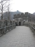
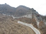
According to our Lonely Planet guidebook, after traversing the Great Wall we had two choices for returning to the parking area where we’d catch a ride back to Dandong. We could either follow the river on a narrow dirt path or choose a hiking trail along the cliff face. The couple we were travelling with expressed a preference for the easier riverside trail but I was secretly delighted when we couldn’t locate it and had to set off along the more challenging route instead! We shared it with many other people and didn’t actually see anyone below us so I’m assuming that the easier path isn’t there anymore. Instead, we looked down on the fence that ran along our side of the river and separated us from North Korea.

Even though I’ve pretty much managed to overcome my lifelong fear of heights, as we went along I was very thankful for the sturdy metal fence that provided both protection from falling and a handrail when it was needed. In places, the hike was an easy one but we also scrambled up, down and over some rocky faces that were quite challenging. Then, as we neared the end of the path, we came upon a suspension bridge! In the past, that would have finished me off but instead I was able to enjoy it and even provide encouragement for one of our companions whose fear was written all over his face.

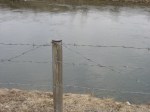
Shortly before we reached the end of our journey, we reached the spot known as Yibukua or ‘one step across’, a particularly narrow part of the river between the two countries. Perhaps the water is high at this time of year because it would have taken more than one giant step to cross it but regardless, the barbed wire fence made it impossible for anyone foolish enough to try. Signs also made it very clear that we shouldn’t attempt to cross and if that wasn’t enough deterrent, the gun-toting North Korean soldiers patrolling in the distance definitely would be.

At no point did we feel that we were in any danger though. Chinese tourists do visit North Korea and we probably could too but I doubt that we ever will. I do feel like I should have a stamp on my passport that says that I was one step away though!

Great Wall, fantastic experience!

How can I possibly put the Great Wall of China, the most enormous construction project in human history, into words that truly do it justice? For most of my life I couldn’t possibly have imagined that I would one day stand on this historic structure but that’s exactly what I did on Friday morning!

Known as Tiger Mountain Great Wall, the segment of the wall located about 12 km northeast of Dandong sees far fewer tourists than the sections that are closer to Beijing. Built during the Ming Dynasty (1368-1664), it runs parallel to the North Korean border and is the easternmost section of the Great Wall. Buffeted by wind and rain for more than 500 years, the wall had fallen into ruin until a large scale restoration project was begun in 1992. Now fully restored, it snakes its way up the steep mountainside to a height of 146.3 metres. One of three watchtowers stands like a beacon at the peak and provides a panoramic view across the Yalu River and into North Korea. From the peak, the wall makes a quick descent down the back side of the mountain ending near a narrow branch of the river.

As we left our bus and walked up the road toward it, seeing the Great Wall winding its way up the hillside in the morning mist was an absolute thrill. Of course, we couldn’t help wondering how well our old knees would handle the climb but I think the sheer exhilaration of being there helped carry us up the steep incline.

The forecast called for rain on Friday but Colleen (the redhead in one of the photos) and I are convinced that the umbrellas in my backpack and the rain cape in her bag were good luck charms as the weather was great; not too warm or too cold, no wind and not a drop of rain all day!

Since it was a holiday in China, we shared the wall with many other people but it wasn’t overly crowded and there was a wonderful sense of camaraderie as we shared this incredible experience with one another. We only heard a few words of English all day but plenty of delighted laughter as people huffed and puffed their way up the steep cement stairs that made up much of the climb. There were also high fives given as well as the universal thumbs up sign.

After reaching the far end of the wall, we enjoyed a fairly challenging hike back to our starting point but I’ll tell you more about that in a future post. For now though, I’m happy to say that our knees survived both the wall and the hike and we weren’t even sore afterward. Obviously, climbing the 67 stairs up to our apartment more than once a day for the past six weeks was excellent preparation!

Gold rush glimpses

From Vancouver to Barkerville, BC is about 750 km (466 miles), a distance that we’d often travel in a day but this summer it took us more than a week! No, we didn’t have car trouble or any other misadventures; we simply took our time and enjoyed the sights. Rather than taking the most direct route home from Vancouver the way we usually do, we decided to follow BC’s historic gold rush trail and we were in no hurry. What a great way to travel!

Billy Barker’s discovery of gold on Williams Creek in 1862 triggered a stampede of thousands of miners to the area. Travelling the Cariboo Waggon Road, their trip through steep canyons,  raging rivers and high mountain passes was a long and arduous one. Many of today’s highways follow that trail and along the way many remnants of their journey remain for today’s traveller to explore.

   credit

Searching for geocaches led us to many sites that we might otherwise have missed… Cemeteries like this one just outside the historic community of Yale where graves date back to the 1860s, some 40 years before the part of Canada that we call home was settled.

And churches like St. John the Divine Anglican, also in Yale, which was built in 1863 and is the oldest church in BC that still stands on its original foundation.

The early 1860s saw the construction of a series of roadhouses along the banks of the Fraser and Thompson rivers. Usually within a day’s ride of each other, these were places where weary travellers on their way to the gold fields further north could rest for the night, have a meal, and water and feed their horses. At historic Hat Creek Ranch between Cache Creek and Clinton, the location of one of these roadhouses, the buildings stand as they did in 1901 but some were built as early as 1860. We spent an afternoon there exploring the exhibits and even riding an old time stagecoach!

Next to Hat Creek Ranch is the very interesting Stucwtewsemc (Sluck-TOW-uhsen) Native Interpretation Site where we were able to see how the original occupants of the area lived. I have studied both the coastal and the plains natives quite extensively but I knew virtually nothing about these people who lived between the two. I found the kekuli lodge, or pithouse, particularly interesting. Built half underground and half above, a typical kekuli housed between 25 and 30 family members, from grandparents down to grandchildren, throughout the winter months.

With so much to see and do along the way, some days we didn’t travel very far at all. When we left a campground in the morning, we often had no idea what that day would hold or where we’d sleep that night. For example, one day we travelled only 112 km (70 miles) from Clinton to Lac La Hache Provincial Park but along the way we found six geocaches, hiked to the Mount Begbie fire lookout tower named after the swashbuckling chief justice who established law and order on the BC frontier during gold rush days, and played 18 holes of golf on the beautiful 108 Mile Resort course. I’d call that a productive day, wouldn’t you?

Now that we’re home and have internet access again, there’s much more to share including our visit to Barkerville itself but I’ll save that for future posts.

Here comes the bride!

On a misty summer morning ten years ago my cousin was married in the First Nations feasthouse on the top of Grouse Mountain overlooking Vancouver, BC. Though he arrived via the Grouse Grind, a challenging 2.9 km hiking trail that climbs 2800 feet up the face of the mountain, his bride and most of the guests took the easier way up the mountain arriving via the Skyride, North America’s largest aerial tramway.

On Friday, we attended another mountain wedding. Our niece , Stacey, was married high above Sun Peaks Resort near Kamloops, BC. This time the bridal party and their guests, including Stacey’s 88-year-old grandmother, arrived via chairlift!

It was a beautiful sunny day and the setting was spectacular.

The ceremony was simple and meaningful. It was truly a family celebration with Stacey’s brother, Martin, as her “man of honour” and Gerhard’s father and older brother as his two groomsmen. Even Odin, their beloved canine was present! Richard was honoured to be asked to bring a blessing.

Congratulations, Stacey and Gerhard! May all your days be blessed and may your life together be as beautiful as the day on the mountain!

Rainforest!

We explored the Costa Rican rainforest from every angle! The views from the back balcony of our little cabin were spectacular.


By far the most fun, however, was flying through the treetops on our zip-line canopy tour! I can now say with absolute certainty that I have overcome my fear of heights! It was an absolute blast and there wasn’t a moment of fear!  Securely fastened into our harnesses and attached to the cable by pulley, we wore thickly padded leather gloves on one hand to use as a brake as we approached each platform. Eleven cables ranging in length from 50 to 500 metres in length took us from platform to platform high in the treetops. Totally exhilarating! The only negative thing I can say is that it was over way too soon! If you haven’t tried zip-lining, I definitely suggest adding it to your bucket list! I’d do it again in a heartbeat!

We did our zip-lining at Hotel Los Lagos which was just down the road from where we were staying. Though the views from the cable were spectacular there really wasn’t time to pick out any wildlife hiding in the canopy. After the tour, however, we had full use of the Los Lagos grounds for the rest of the afternoon. That included soaking in their many hillside hotspring pools and exploring their gardens complete with a few rainforest animals. I wouldn’t have minded meeting this one in the wild

but I’m glad we didn’t come across this one on our next adventure!

The hike to La Fortuna waterfall was an easy one, one that we could have done on our own with no difficulty but a guided hike was part of our package. It was supposed to be a group hike but as it turned out, Richard and I were the group! No one else had signed up for that particular excursion so we had David all to ourselves and what a delight that was! Not only was he a very pleasant hiking companion but he was incredibly knowledgeable about the flora and fauna of the rainforest as well as his country in general. With the aid of his sharp eye and ear, we saw all sorts of things that we might have walked right past without noticing… howler monkeys resting on a branch high above us, a mother sloth with her baby moving ever so slowly through the canopy, and a wide variety of birds including a brightly coloured toucan. All of these were too far away for me to capture them with my point and shoot camera but we enjoyed close-up views through David’s binoculars and though they’re not be recorded on film they’re definitely etched in memory.


The waterfall itself is a 70 metre ribbon of water plunging into an emerald pool below. We expected the water to be icy cold and while it was a bit chilly getting in, it really wasn’t unpleasant at all. Many swimmers have lost their lives by venturing too close to the cascading water and being pulled under by its force. I can certainly see why. Once we were in the water, the sheer magnitude and power of the falling water seemed to beckon us to draw closer but we wisely chose not to! Instead, after a short swim below the falls, we moved downstream to a quieter pool for a more leisurely swim.

Packing again!

On what is perhaps the coldest day of winter so far I’m taking out my summer clothes! Why, you ask? Because I’m packing again!

Back in October, when Richard and I celebrated our 35th wedding anniversary, we decided to celebrate by taking a mid winter vacation to someplace warm. I searched the internet for possibilities. I considered a cruise. In fact, I almost booked a seven day western Caribbean excursion but it just didn’t feel right. I thought about an all-inclusive resort vacation and considered all sorts of sunny destinations. That didn’t feel right either. I thought about renting a condo on a beach somewhere. That was appealing but then along came just the right thing… a Costa Rican adventure!

I was looking for something that wouldn’t take as much planning on my part as some of our Asian adventures required and something where we’d feel a little more pampered. On the other hand, we simply couldn’t see ourselves sitting in a luxury resort sipping cool drinks by the pool for an entire week. Not that that doesn’t have appeal but we can do that when we’re too old for more adventurous pursuits.

So what will we be doing? We’ll fly out on Thursday morning and begin with three days at a beach resort on the Pacific coast. Then we’ll move inland to Arenal Volcano National Park where we’re looking forward to doing some hiking and get this… the lady who has worked hard at overcoming her fear of heights is going to experience the rain forest from above on a zip line canopy tour! They may have to push me off the first platform but I can hardly wait!

Our package includes almost everything including a rental car to get from place to place. All we’ll be responsible for is finding lunch and supper each day which means we’ll be free to sample a variety of eating places and local cuisines.

In addition to commemorating our 35 years together, this vacation is also going to be a much needed digital detox for both us. As much as I love the internet, it’s easy to let it to consume more of our time than it ought to so the laptop is staying home this time and we won’t be searching out internet cafes. I’ll definitely be blogging about our adventures but not until we get home. We’ll only be gone for a week though so stay tuned!

A quieter way of living

Friends from the city came out to spend the long weekend with us. Every once in awhile, they like to leave the noise and pressures of their busy city lives behind and relax in the quiet solitude that rural living offers. Late Saturday afternoon after sitting around and visiting for several hours, we decided to go for a walk. Supper was delayed as we ended up walking out to the lake north of town and exploring the newly upgraded nature trail that runs along it’s edge. That evening, our next door neighbours joined us as we relaxed by our backyard firepit and the city dwellers exclaimed over the myriad of stars stretched across the night sky above us.

Yesterday took us out into the wide open spaces again as we fulfilled one of my long time desires. Two of the fields that Richard and I farm sit at the top of a bluff with an amazing view. Every spring and fall as I’ve come to the edge of those fields and enjoyed the vista spread out below, I’ve dreamed of hiking up from the bottom. After spending the morning in church and returning home for lunch, we set off to do just that. It turned out to be a much easier hike than we anticipated.

As we walked across the bottom pastureland and made our way up the hillside, what looked like nothing more than grass from the distance became a wide variety of plants including low lying junipers, colourful wildflowers and even tiny cactus. A deer bounded away as we came close and we saw the remains of a couple of others who didn’t make it through the harsh winter, their bones picked clean by hungry predators.

I love cities. I spent my teenage years in Vancouver and went to university in Calgary. I’ve walked the streets of Toronto, Montreal, Tokyo, Seoul and Hong Kong but I also love coming home to the wide open spaces and a quieter way of living. As our friends go home today, I hope they’ve been refreshed.

Bird Island hike

With this morning’s hike to Bird Island, we crossed the last item off our Saipan Bucket List today! Yes, we actually did write one! I wanted to make sure we didn’t miss anything.

Bird Island from the viewpoint

According to the atlas, we’d drive to the end of Bird Island Lane and then hike down to the water’s edge. It didn’t look very far.

Isn’t this where you’d expect Bird Island Lane to begin? Me too. Pretty easy. No yellow shorts this time. The only problem was, there wasn’t a lane there. No road of any kind. There was the beginning of a trail though so we guessed we’d have to walk a little further than we’d anticipated and set off. It was an easy, well marked and mostly level path through the jungle. We knew we were going in the right direction because we could hear the ocean in the distance.

Suddenly, after walking for awhile, we came upon a road! Apparently, Bird Island Lane did exist, just not where the sign said it was! Weird! Sure enough, there was the actual trailhead too.  From that point on, it was a fairly steep descent but, like the trail to Old Man by the Sea, there were ropes to help us down the steep, slippery parts.

Soon, we emerged on the beach. The tide was high so we couldn’t get close to Bird Island itself but we walked the narrow sandy beach from one end to the other, explored a small cave at one end and climbed over rocks at the other. What a beautiful spot!


We’re close to the equator here and with the tropical sun beating down on us and it’s heat reflected back at us by the white coral sand, it was really hot on the beach! We cooled off with a dip in the Grotto on our way home. This time we had our masks and snorkels with us so we could actually see the fish and watch the scuba divers deep below. It amazes me that there are lots of people living on the island who have never swam in the Grotto and we’ve been there three times already!

Though this is a tiny island and we’ve explored it pretty extensively, I know that there are still more hikes that could be done and beaches that could be seen. With close to two weeks left, though, we’ve seen and done all the things we most wanted to do which is good because we’ll be busy with Vacation Bible School every day next week. Ministry is, after all, the main reason we’re here!

Oh rats!

It’s early Friday afternoon and everything is ready for the weekend so what do we do with the rest of this dreary wet day? It’s been raining non stop for about 18 hours! Fortunately, I’ve been keeping a list of things to blog about!

With the exception of birds and sea life, Saipan doesn’t appear to have much in the way of wildlife. What it does have, however, is rats! For a girl from Alberta, Canada’s only rat free province, this was a little disconcerting but I quickly got used to seeing the occasional rat scurry across the porch. They weren’t as big and ugly as I expected them to be but when I discovered that they were raiding the cat’s dish I decided to take action. I started bringing the dish into the house after the cat had her morning meal. That seems to have taken care of the problem. I haven’t seen a rat for awhile and the kitty has learned to wait patiently at the door every morning for me to bring her her food.

Though we’re not willing to share the porch with the rats, we’re quite happy to share it with the geckos. After all, these cute little lizards eat insects and they’re really quite fascinating. They actually have adhesive feet that allow them to walk across the ceiling or scurry up a pane of glass! And did you know that geckos chirp? I didn’t. Geckos are nocturnal so we rarely see them until after sunset. I’d noticed the occasional loud chirp in the evenings but it took awhile for me to realize that it might be coming from these tiny critters. Sure enough, according to Wikipedia, geckos are unique amongst lizards in their ability to vocalize. Apparently, they make these chirping sounds to interact with other geckos. If you want to hear what they sound like, click here.

It’s kind of nice when we’re hiking through the jungle to know that we’re not going to round a corner and come face to face with a bear as we might in the Canadian wilds. I suppose a tiger or a leopard might be more fitting but they aren’t here either. In fact, there aren’t even any dangerous snakes. There’s actually a program that actively works to keep the the island snake free, much like Alberta’s rat control program. If you see a snake, you’re supposed to kill it then immediately call 28-SNAKE! Hmm… I hope I don’t see one. I’m not really up on the best way to kill a snake!

By far the biggest animal control issue on the island is the stray dogs. According to a recent survey there are an estimated 10 000 to 20 000 of them and the number continues to increase! The municipality has recently introduced a licensing program for dogs and already pet owners have registered approximately 1000 of them. Apparently, the revenue generated will be use to build a permanent animal shelter but clearly it won’t be able to house the thousands of unwanted animals that wander the streets. Sad.

When all else fails…

You know the old saying “When all else fails, read the instructions.”  After today’s experience, we might say “When all else fails, pay close attention to the instructions!”

Hiking to the Old Man By the Sea was on our list of things to do but we weren’t sure how to get there. We’d been up the right road but hadn’t seen any signs or indications that there was a trail in the area. When we saw Brian at the street market on Thursday evening, we asked him about it. He’d hiked to the Dry Grotto with us so we thought he might know the way. That’s easy, he told us; someone hung a pair of yellow shorts on a tree to mark the way! When he and his wife, Rachel, heard that we’d already hiked to Forbidden Island, they assured us that the Old Man hike was much shorter and easier.

When this morning’s rain turned to sunshine, we decided to try the hike this afternoon. Just to be sure we knew where we were going, I decided to check the atlas. It showed San Ignacio Drive leading to the shore close to the Old Man By the Sea so I kept that in mind and off we went. We passed the yellow shorts and sure enough, there was San Ignacio Drive just a short distance up the road. San Ignacio Drive is a rather pretentious name for what was little more than a path! We were glad we’d taken the vehicle with 4 wheel drive!

At the end of the road, we came to a clearing, parked the vehicle and began to look for the trailhead. There was nothing obvious but we found what we thought might be the trail and followed it. Almost immediately, we could hear the thunderous sound of waves crashing far below us and we soon came to the edge of a precipice. This is what we saw:

We skirted along the edge of the drop off and continued to follow what we hoped was our trail. Soon it began to descend steeply. Richard went ahead to see if this really was the right way while I stood on top of the world, or so it seemed, and enjoyed the spectacular view.

I was pretty sure that the little beach at the right was where we wanted to be but could we get there from here? Richard returned and said that he thought this was probably the trail so we began our climb down steep rugged rock. Could this really be the way? It certainly wasn’t easier than the hike to Forbidden Island. On we went, though. Soon we could see what I was sure was the back side of the Old Man. There he is, the hump in the centre of the picture.

Unfortunately, though our destination was now clearly in sight, we came to the edge of a cliff and had to admit that we definitely weren’t on the right trail. Feeling a bit discouraged but also glad that we’d seen the amazing sights along the way, we returned to the vehicle thinking that perhaps we’d have to call Brian and see if he’d come with us next time.

As we headed back up San Ignacio Drive toward the main road, a thought struck me. What if we weren’t supposed to be on San Ignacio at all? What if the trail actually started right where the yellow shorts were hanging? Sure enough, when we got back to that spot, there was another vehicle parked at the side of the road and close inspection revealed an easy path leading into the bush! It couldn’t be seen from a vehicle passing by but it was there!

There were even ropes to help us up and down a few steep slippery spots.

When we emerged from the jungle, there he was, the Old Man By the Sea silently surveying his domain!

What an amazing formation!

The little beach was strewn with litter; everything from toothbrushes to toys! Shoes without partners were abundant. These weren’t things left behind by careless hikers but had washed up on shore after riding the waves from who knows where.

As we explored, we even found this and took a photo for Nathan, our cave loving son. Like most of the caves on the island, it isn’t very deep but it’s probably provided shelter for more than one unlucky hiker caught in a storm.

I could have stayed a long time watching the waves crash against the shore but soon it was time to go. After all, it gets dark early on Saipan and it wouldn’t be a good idea to be caught out on the trail after sundown.

There’s still at least one more hike we want to do while we’re on the island. I hope that one’s not as difficult to find and if we have to ask for directions, we’d better follow them more carefully!