Shalom Israel!

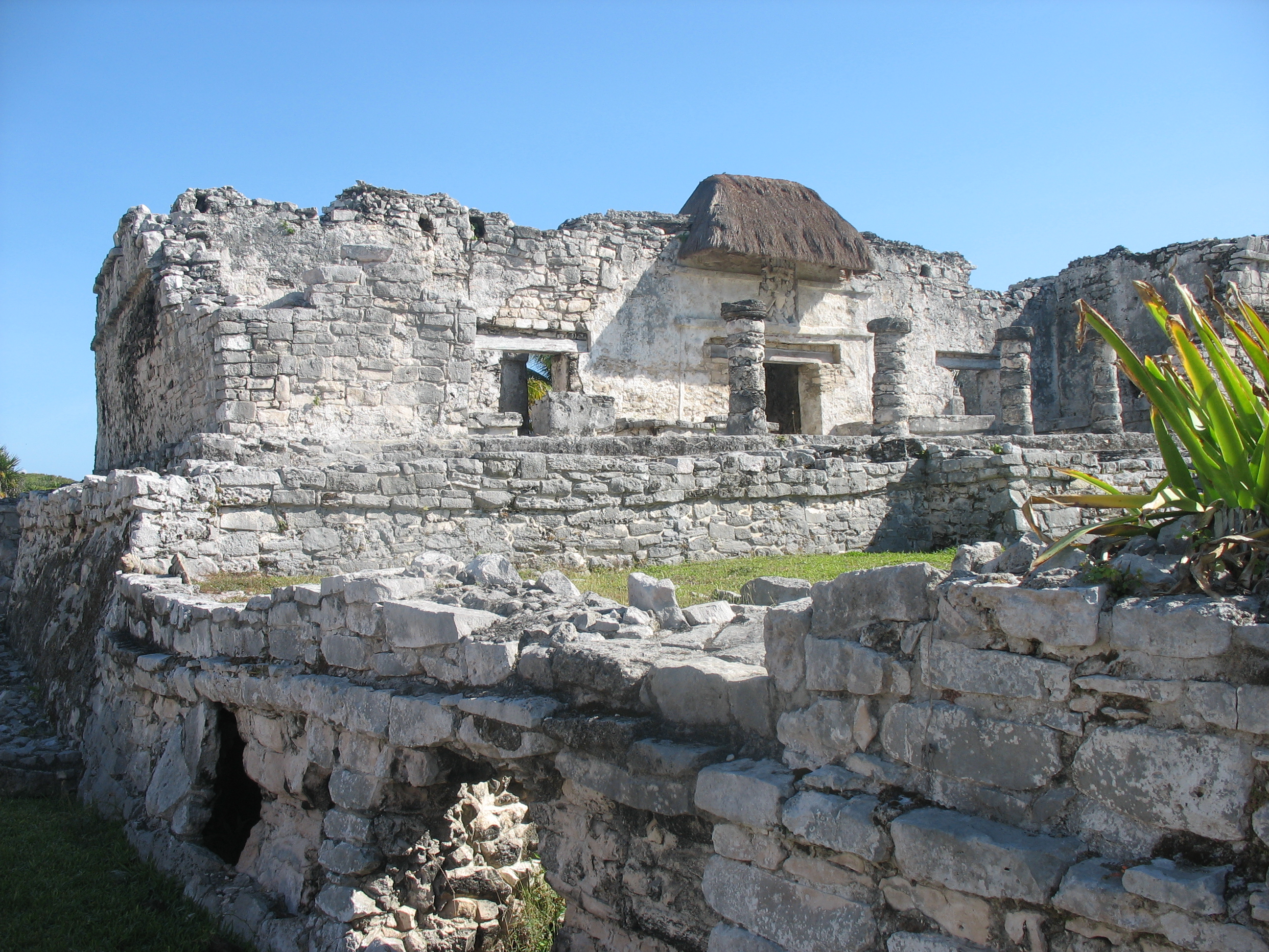
As I begin to process and share all that we saw and experienced on our pilgrimage to Israel, I am reminded that there is a fine line between worshipping at a place and worshipping the place itself. There is no holy magic to any of the sites that we visited, but I have no doubt that being there and seeing them with our own eyes will give greater context to scripture as we continue to read and study it; to make it come alive or, as Richard says, to help us see it in 3D. As we traveled the length and breadth of this small country, I think everyone in our group gained a greater appreciation for the land that our Saviour traversed and for the ways in which He used His environment in His teachings.

We arrived in Israel on January 22nd via a direct ten hour flight from Toronto to Tel Aviv. The ultra modern Ben Gurion International Airport, named after the country’s first prime minister, is the world’s gateway to Israel.

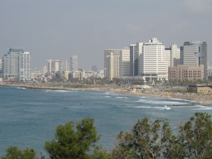
Tel Aviv is a vibrant, modern and very liberal city located on the eastern shore of the Mediterranean Sea. Its next door neighbour is the ancient port city of Jaffa (Joppa). The two cities have grown together to form one metropolitan area with no line of distinction between them.

IMG_0138

Jaffa is of both Old and New Testament significance. It was here that Jonah boarded a ship headed for Tarshish in an attempt to flee from the mission that the Lord had given him. (Jonah 1:3) Much later, in the book of Acts, we are told that Peter was staying in Joppa with a tanner named Simon when he was summoned by Cornelius, a Roman centurion in Caesarea, to come and share the good news of Christ with him and those who had gathered in his home. (Acts 9:43-10:48) We were reminded that we can choose to be like Jonah and stand in God’s way or like Peter who cooperated with God. (Acts 11:17)

IMG_0128

IMG_0151  IMG_0150

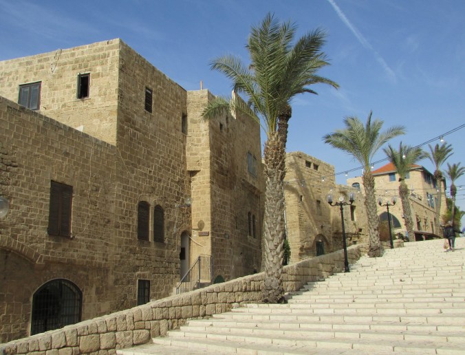
Walking through the narrow stone alleyways of historical Jaffa, we came to the purported house of Simon the Tanner. There we were reminded that there are, in Israel, two types of Biblical sites; those that may be/might be/ are traditionally thought to be the original sites and those that definitely are. Simon’s house clearly falls into the first category. The present house simply doesn’t date back to the first century AD, but it is in the approximate location of the original home.

IMG_0146

Returning to Tel Aviv proper, we spent about an hour exploring the colourful Friday market which reminded Richard and I of similar marketplaces in Korea and Cambodia.

IMG_0160

After checking into the lovely Dan Tel Aviv Hotel where every room has a view of the Mediterranean Sea, Richard and I went for a stroll along the promenade overlooking the rocky shore to a sandy beach where, in spite of the coolness of the day, I shed my shoes and socks, rolled up my pant legs and fulfilled my dream of wading in the Mediterranean Sea!

IMG_0181

IMG_0177


October!

“I’m so glad I live in a world where there are Octobers.”
L.M. Montgomery, Anne of Green Gables

October is my favourite month; a bittersweet interlude between summer and winter. Here in Alberta, it arrives amidst a blaze of colour, but by the end of the month, there will likely be snow on the ground. Each golden day is a treasure.

The tiny hamlet of Gwynne, located midway between Camrose and Wetaskiwin, is nestled in a valley that is absolutely gorgeous in the fall. We often take that route on our way to Edmonton, but until today we’d never stopped to explore the area. I recently learned of two hiking trails in the valley, however, and they were today’s destination.

The first, officially called the CPR Canyon Hiking Trail, is a relatively easy 4 km walk along a creek. The name seems apt as the railway follows the creek on the opposite bank and three trains rumbled by while we were hiking. It’s known locally, however, as Chickadee Trail and we soon found out why!

The inquisitive little critters were landing on my outstretched hand before we even took any food out of the pack on Richard’s back. Soon we were sharing lunch!

IMG_5726

IMG_5730 - Version 2

There were six geocaches hidden along the trail which added to our fun.

The second trail circled through Pipestone Creek Conservation Lands where we searched out three more geocaches and enjoyed some spectacular views including an oxbow lake.

IMG_5760

There are clearly many more trails criss-crossing the conservation area and we found a lovely little campground close by, so I suspect that we’ll be spending more time there in the future.

IMG_5741

I have no idea how far we walked today, but my knees are telling the tale this evening and it’s time to go soak in a hot bath!

IMG_5735

Hopefully October holds many more days like this one!

Fall camping

IMG_5618I’ve always wanted to go camping in the fall; always hoped for just one more outing with the trailer before winter hit. As teachers, it never happened. We were back in the classroom and up to our eyeballs in work by late August or the first week of September. Then, with retirement came several years of helping our friend, Louis, with harvest. I loved being out on the combine, but it meant that there was no time for camping in the fall.

Finally, this year it happened! We packed up the trailer last Wednesday morning and headed for Miquelon Lake Provincial Park, less than an hour and a half from home. Surrounded by the spectacular colours of the season, fall camping was everything I always thought it would be! Though we got caught in the rain while out geocaching on Wednesday afternoon, the clouds soon disappeared and for the remainder of our time the weather was glorious.

Here in Alberta, we don’t get the wide variety of fall colours that are found in eastern Canada, but everywhere I turned I was surrounded by beauty and I took dozens of pictures!

IMG_5594  IMG_5617

IMG_5633

We found 14 geocaches within the park boundaries, but the highlight of our trip was definitely Friday’s hike. We left the trailhead late in the morning intending to hike 7.3 kilometres, but we’d completed all but 1.5 km of that by the time we stopped to eat lunch! Digging out our trail map, we quickly decided to add what we had originally thought might be a separate hike sometime in the future. In the end, we covered 13.2 km! Considering the fact that just a few months ago, I couldn’t walk more than two km without playing out, I was pretty stoked!

IMG_5608  IMG_5613

IMG_5647

Those of you who’ve been reading my blog for very long know how much we enjoy exploring old abandoned houses that give us glimpses into life in days gone by. Imagine our surprise and delight when Richard spotted an old brick chimney rising out of the bush a short distance from the trail. Of course, we had to take a closer look! Although the girl manning the park office couldn’t give us any information about the house or its original inhabitants, it was easy to see that the two storey structure and its smaller outbuilding must have been there long before the park was established in 1958.

IMG_5663

IMG_5652

IMG_5659

Though we didn’t see any of the larger wildlife, including deer, moose and elk, that live within the park, there was clear evidence of their presence along the trails. Plenty of fresh hoof prints and droppings told us they weren’t far off. What we did see were squirrels, muskrat, tiny frogs, a surprising number of garter snakes and an abundance of water fowl. As Miquelon Lake and the numerous wetland areas within the park are located within two of North America’s migratory flyways, flocks of migrating geese honked their way overhead and settled on the lake each evening.

Miquelon Lake is also part of the Beaver Hills Dark Sky Preserve, an an area that has been established to reduce the glare of artificial light and increase the visibility of the night sky. Each evening, as we sat around the fire in the crisp evening air, darkness settled around us and stars filled the sky. What could be more relaxing?

Dare I hope for one more camping trip before winter arrives?

IMG_5623

Donalda day trip

Every time we travel Highway 53 on our way to Red Deer, Calgary or other points to the south, we dip down into Meeting Creek Coulee, the northern most point of the Canadian Badlands. As we climb back out, we pass the access road to the tiny village of Donalda. With its population of about 260 people, it perches on a bluff overlooking the vast valley below. Over the years, we’ve often thought that this would be a great area to go hiking and apparently, we weren’t the only ones. A few years back, the community developed and advertised a hiking trail. When we discovered that geocachers had hidden some caches both in town and along the trail, our interest grew and finally, yesterday was the day. We packed a picnic lunch and off we went! IMG_5318Donalda’s greatest claim to fame is the world’s largest lamp, a replica of the oil lamps that once lit the homes of early settlers across this land. Standing 42 feet tall at the end of the town’s quaint main street and just across the corner from a museum that houses the world’s largest collection of oil lamps, it was lit for the first time on July 1, 2000. All night, every night, its light shines out over the valley below. Inside its base, visitors enjoy a series of paintings depicting the town in its earlier days. Our first cache was hidden just outside. IMG_5327 IMG_5323  IMG_5322 IMG_5321 IMG_5316 After picnicking close to the lamp and the restored railway station nearby, we searched out the other two caches that are hidden in town and then set off along the hiking trail. We expected to find ourselves walking along the rim of the coulee, but instead, we followed a woodland trail that eventually led us out onto an open bluff overlooking the valley below. Seldom ones to stay on the beaten track, after stopping to rest at a picnic table with a spectacular view, we set off to follow an animal trail down into the valley. IMG_5351 I hiked down to the flat valley floor while Richard explored the interesting formations on another close by bluff. IMG_5344 IMG_5345 IMG_5346 The valley is far vaster than we ever realized from the highway and my photos hardly do it justice, but it was great to finally trek through a very small part of it. There are so many interesting places close to home if one but takes the time to explore them! IMG_5334 IMG_5335 IMG_5336

Magical Mystery Tour

Several weeks ago, an insert appeared in our Sunday Morning church bulletin advertising the SCCN (Sedgewick Community Church of the Nazarene) Magical Mystery Tour. “Come ride the bus to our unannounced destination for a fantastic fun filled day of fellowship and food” it proclaimed. Today’s date was given, but very few other details.

I checked the calendar and the day was open. What fun! Those of you who know me well or who’ve been following my blog for very long know that I like nothing better than packing up and going somewhere. Anywhere, whether it be a day trip or a year in Japan, I’m game to go! It’s the gypsy in my blood!

At 10:30 this morning approximately 30 of us gathered in front of the church. “Where do you think we’re going?” some asked while others tried to guess. The 32 passenger County of Flagstaff community bus pulled up and we knew we’d be traveling in style. With temperatures of over 30ºC forecast, we’d definitely appreciate the air conditioning!

IMG_5287 - Version 2  IMG_5286

I’ve always been the travel planner in our family. For me, part of the fun of traveling is the planning that usually goes into it, but today I felt like a kid climbing aboard the bus with absolutely no idea where it was going to take me! Soon we were headed north, passing vast fields of bright yellow canola in bloom. Perhaps we were going to Viking, hometown of the Sutters, one of the most famous families in NHL history. Six of the seven Sutter brothers made it to the National Hockey League in the 1970s and 80s and four of them went on to become coaches and general managers. Half an hour north of Sedgewick, Viking is also hometown to our Mystery Tour organizer. Perhaps she knew of something interesting for us to do in the small town of just over 1000 people. But no, the bus continued onward.

When we turned west on Highway 16, we began to speculate that our destination might be Vegreville, home of the world’s largest pysanka (Ukrainian Easter egg). Sure enough, though we passed by the giant egg, the bus pulled into town and stopped at the historic train station. Built in 1930, it now houses the Station Cafe where a delicious buffet of authentic Ukrainian food awaited us. After relaxing around the tables, we were given a tour of the building. Many of us decided that we’d happily move into the beautifully renovated upper story that once housed the station master’s family.

IMG_5303  IMG_5297 - Version 2

IMG_5306 - Version 2

Our second stop was, in fact, the park with the 9.4 metre high pysanka that reflects the traditional art of the many Ukrainian settlers who made this part of Alberta their home.

IMG_5309

A stop for ice cream in Viking on the way home rounded out our day. Though the results of my most recent glucose tests were pretty good, I am pre diabetic and I’d already indulged in a small dessert back at the train station so I knew I’d better forgo another sweet treat. Besides, after filling up on cabbage rolls, perogies and other Ukrainian delights, I wasn’t the least bit hungry!

The Magical Mystery Tour was definitely all that it promised to be; a day filled with fun, fellowship and fantastic food. In fact, some of us are hoping that a new SCCN tradition has been born!

20150711_143001photo: Doris Johnson

The old farmstead

If you’ve been following my blog for very long, you may remember how much I enjoy exploring the old farmsteads scattered across the prairie. If only walls could talk, what stories they would tell!

Today, we made the one hour drive to Wainwright to pick up a piece that Richard had ordered for the golf cart. On the way, we passed an old abandoned house hiding behind an abundance of beautiful lilacs. As always, I was intrigued.

in lilacs

When we arrived in Wainwright, we discovered that the wrong part had been ordered! Fortunately, the trip was not for naught. We went out for lunch, did a bit of much needed shopping and found eight geocaches before heading for home. On the way back, Richard slowed the vehicle as we once again approached the old house hiding behind the lilac bushes.

“Do you want to stop?” he asked, already knowing what the answer would be. Of course, I did!

6

3

Can you imagine sitting in the shade on the front porch gazing across the open prairie or watching the stars come out at night?

4

The floor is rotted out in places, exposing the root cellar under the kitchen, so we didn’t walk around inside but it was easy to take photos through the open windows and doors. Who slept in the two small bedrooms, I wondered, and what did they dream about? I’m sure that many good times were had as well as challenges met under that roof.

5

7

Before we left, Richard took out his trusty pocket knife and snipped off a few sprigs of lilac. I have no idea who planted those bushes, now so overgrown, but their heavenly scent now fills my kitchen!

IMG_5220

IMG_5224 - Version 2

Solitude

IMG_5153

Richard and I spent the past couple of days doing three of the things that we most enjoy at this time of year… camping, hiking and geocaching.

Big Knife Provincial Park, located in central east Alberta where Big Knife Creek flows into the Battle River, is less than an hour from home for us. Like many locations on the Canadian prairie, it takes it’s name from our native history. Two hundred years ago, the Blackfoot and Cree who inhabited the area were bitter enemies. According to legend, Big Man, a Cree, and Knife, a Blackfoot, fought near the banks of the creek, which at this time of year is little more than a muddy breeding ground for mosquitoes. Apparently both warriors died in the battle.

Though the campground and day use areas are probably somewhat busier on weekends and during the height of the summer, the park was almost empty while we were there providing us the peace and solitude we were looking for. We spent several hours on Wednesday tramping the River Flats trail system and yesterday we hiked the Highland trails. Though my stamina isn’t quite what I’m used to it being and we stopped to rest more often than we might have in the past, I was impressed that I could quite easily hike for several hours a day without completely wearing out.

The trails were far from challenging, mostly level and grass covered. With the sun shining overhead, tiny wildflowers strewn along our path, butterflies flitting around our ankles, birds singing in the nearby trees, and the sweet musky scent of the silver willow bushes wafting on the breeze, walking was a delight. We did do a bit of “real” hiking though, first leaving the River Flats trails to get a close-up view of the nearby hoodoos, then deciding to climb a steep hill and follow a narrow animal track along the top of a bluff that would have scared me out of my wits a few years ago before I overcame my fear of heights.

IMG_5151

IMG_5157

IMG_5166

IMG_5170

Only one of the eleven geocaches hidden throughout the park eluded us. It was suppose to be at the end of that narrow animal track, though the cacher who placed it recommended coming at it from the other direction. We searched a wide area around the given coordinates but came up empty handed. The view was spectacular though and the trek well worth it.

IMG_5171

There’s a cache up there somewhere… maybe

Not all of the caches were out on the trails. Shortly before dusk, we spotted a beaver in the water’s edge munching on a stick while we were searching for the one that’s hidden not too far from the boat launch. I couldn’t get close enough to get a good photo, but we stood and watched him until he quietly slid into the water and swam away.

IMG_5177

Storm brewing

I love the solitude of nature; no TV, no telephone, and no internet, but I also love the conveniences of modern day camping. On Wednesday night, a storm blew in bringing much needed rain to the surrounding countryside but we were snug and warm in our trailer bed as the thunder crashed and lightning flashed. It had blown over long before morning came and oh, how well I slept!

Tulum

One of the reasons that we chose a resort on the Riviera Maya for our Mexican getaway was its close proximity to the Mayan ruins at Tulum. Visiting this historic site was definitely one of the highlights of our vacation.

I was awed by its location high on a limestone cliff overlooking the beautiful turquoise waters of the Caribbean. The original Mayan name for the settlement was Zama meaning dawn, very apt considering it’s eastern exposure facing the rising sun. It was early explorers who gave the place it’s current name which simply means wall, referring to the stone barricade surrounding it on three sides. The ocean provides protection on the fourth. Tulum was the only Mayan city built on the coast and one of few that were walled.

Within those walls are found the imposing Castillo, or castle, Tulum’s tallest and most famous building. Standing atop the 12 metre bluff, it has a commanding view of the ocean and many miles of coastline. Other buildings that remain today formed the city’s centre where ceremonial and political activities took place. They include the king’s palace, a meeting hall and several temples. Stone outlines are all that remain of lesser buildings that were mostly built of wood.

Tulum was a seaport and a centre of trade. A grassy expanse in front of the palace was once a bustling marketplace. Below, an opening in the offshore reef leads directly into a small cove, its sandy beach a perfect parking lot for trading canoes.

The earliest date found at the site is A.D. 564, inscribed on a stelae, but its heyday is thought to have been between 1000 and 1600 A.D. Looking at the heavy stone structures, the graceful columns and the intricate carvings that can still be seen on some of the walls, one can only wonder at the architectural achievements of the settlement’s early inhabitants and ponder what might have brought about the demise of such a civilization.

El Castillo

IMG_4750

IMG_4791

IMG_4796

King’s Palace

IMG_4738 - Version 2

‘Parking lot’ with lighthouse in the distance

IMG_4756

Other structures

IMG_4743

IMG_4742

Present day inhabitants!

IMG_4740

We didn’t actually have to leave our resort to see ruins. Remains of a small temple to the Mayan goddess of fertility are located on the grounds and next to them, parts of a much larger Spanish chapel where some 120 bodies were found interred. Overlooking the ocean near the beach stands a Mayan lighthouse very similar to the one at Tulum.

Mayan Temple

IMG_4705

Remains of the Spanish chapel

IMG_4821

 The lighthouse

IMG_4838

Rav4 in the Mohave Desert

When I agreed to go to Las Vegas with three of my closest girlfriends, I knew that I would want to get away from the glitz and glamour for a little while and see the Mohave Desert but would the others agree? I know that they would do almost anything for me but would they enjoy it?

See for yourself. Do they look like they’re having fun?

IMG_4504

At first, we considered a tour. In fact, we almost booked a 4 hour Pink Jeep tour. After all, one of the girls loves all things pink and frou frou. Look carefully and you’ll see her pink iPhone in the photo! What could be better than a pink Jeep?

Practicality led the way, however, and we decided that renting a vehicle would be a better option. We wanted a small SUV so we reserved a Toyota Rav4. Sadly, when we went to pick it up early Tuesday morning, that model was unavailable and we were offered an “upgrade” to a minivan. A minivan… are you kidding? Our kids are grown and we’re past our Minivan Mom days! We wanted something sporty! In fact, we’d even considered renting a convertible but again, our practical sides and our purse strings said otherwise. A minivan was what was available though, so minivan it was. No problem, we’re flexible. We simply decided that we were the Rav4 and a group nickname was born!

Renting was definitely the right choice as it allowed us to go at our own pace, spending as much time as we wanted wherever we wanted. The half hour drive out to the Red Rock Canyon National Conservation Area was an easy one. Our first stop was the Visitor Center where we were given a map, some great advice about where to stop and hike, and some valuable tips such as “Watch where you put your hands and feet. Rattlesnakes, scorpions or venomous spiders may be sheltered behind boulders or under rocks and shrubs.” Fortunately, though we saw lots of holes where they may have been hiding, we didn’t see any of those creatures!

IMG_4497

We were a bit disappointed that we didn’t see any of these ones either!

The 13 mile one-way scenic drive gave us ample opportunity to see the area from the vehicle but we were there to hike and explore. Our first stop was the Calico Hills where we were allowed to climb and clamber wherever we wanted. The sights were spectacular and the red rock against the brilliant blue sky was absolutely stunning.

IMG_4499

It was November 11, Remembrance Day or Veteran’s Day as it is known in the US, so we stopped and built a small inukshuk, a Canadian symbol adopted from the Inuit people of our far northern region, and pinned a poppy to his lapel.

IMG_4517

Throughout the Commonwealth, the poppy is a familiar Remembrance Day symbol and people on the streets of Las Vegas recognized us as Canadians because we were wearing them.

On our second hike, in the Willow Springs area, we saw the remnants of an ancient agave roasting pit as well as one of the “Hands Across Time” pictographs waving to us from the canyon wall, reminders of those who made their home in the desert centuries ago.

IMG_4545 - Version 2

There was abundant and interesting plant life in the area, much of it looking like something out of a a Dr. Seuss storybook!

IMG_4561

IMG_4541 - Version 2

As much as I enjoyed Las Vegas itself, it was when we drove away from Red Rock Canyon that I truly felt like I’d had a holiday!

IMG_4563

Las Vegas!

Las Vegas was never on my list of places I most wanted to visit but when three of my closest friends suggested last July that we replace our annual Christmas shopping trip with a trip to Vegas in November, I immediately found myself saying yes! It wasn’t the destination that captured my attention but the opportunity to travel together and enjoy several days of “girlfriend time”.

When we booked the trip last summer, we had no idea how perfect the timing would be. After an unusually long autumn, we woke up to winter on Saturday morning. We drove on icy roads through snow and slush on our way to the airport, happier than ever to be leaving Alberta behind! As the temperature here at home plunged to around -20ºC, we enjoyed daytime temperatures in the +20s in Vegas!

We packed a lot of living and a lot of laughter into the next few days and proved that four Christian women can have a fabulous time in “sin city”! The laughter started Sunday morning when one friend, who shall remain nameless, discovered that she’d forgotten to pack her pants! Not all of them, fortunately. Just the ones that she intended to wear to church that morning. It continued until we arrived home and she found out that the pants had actually been in her suitcase the entire time!

We stayed at the Excalibur Hotel, a fairytale castle near the south end of the Strip.

IMG_4429  IMG_4427

On Sunday afternoon, we strolled the Strip enjoying the sunshine, eating lunch on an outdoor patio and taking in the sights.

IMG_4439

We stopped at the Bellagio Hotel to enjoy the conservatory with its multitude of flowers and floral statues, see the world’s largest chocolate fountain and watch the outdoor fountain show. We visited a few shops along our way. Can you imagine four storeys devoted to anything and everything related to M&M candies? That’s Vegas where everything is over the top!

We took in two shows during our three day stay. We saw the Blue Man Group at the Monte Carlo and The Tournament of Kings back at our own hotel. How does one possibly describe the Blue Man Group? Hilarious! Fun! Unforgettable! Or, according to their own website, “an energetic and innovative combination of music, comedy, and multimedia theatrics.” The Tournament of Kings was a delicious dinner served medieval style with no cutlery while the audience, seated around the outside of an arena, watched the non-stop action of knights on horseback engaging in competition.

IMG_4479

Shows in Vegas are over early in the evening leaving patrons plenty of time to spend at the casinos. I’m not a gambler but I had lots of fun playing the penny machines and when we left for home on Wednesday, I was ahead by a whopping 55 cents! Pretty cheap entertainment!

We shopped til we dropped at Vegas’ two factory outlet malls. Even with our Canadian dollar at an unhealthy low, there were plenty of bargains to be had and one friend was heard to say, “I had money left over so I had to buy more!”

Though there are many strange things to be seen on the Strip after dark (a large hairy man in a wedding dress is probably forever etched in our memories!), we really saw the underbelly of Las Vegas on a late evening visit to Freemont Street. With a zipline overhead and live bands playing, it’s billed as a premier entertainment destination but it felt to us like a carnival gone wrong. There were many, including the scantily clad dancers atop one of the outdoor bars, who would have frozen some pretty intimate body parts if they’d been on an Alberta street but I think we were most disturbed by the two young beauties wearing huge glittery angel wings and very little else who were selling themselves to passersby. Sad.

This trip was more than just our annual Christmas shopping trip in a new location or a girlfriend getaway. It was also a celebration! When we started planning it, I was two-thirds of the way through 30 rounds of radiation. Now, with that ordeal several months behind me, we were celebrating survival and on our final evening in Vegas, my friends treated me to a very special celebration dinner.

The destination didn’t matter but the company did! I am so blessed!

IMG_4433   IMG_4469

IMG_4466