Taking a break

After a mostly sleepless night worrying about how to deal with everything in my parents’ apartment, we decided to take a break today and go on an adventure with our grandsons, Sam and Nate.

Vancouver is enjoying a fabulous October so the drive up the Sea to Sky Highway to Britannia Beach was spectacular. The mine, which operated there from 1904 to 1974, was once the largest producer of copper in the British Empire and is now home to the fascinating Britannia Mine Museum. There the boys enjoyed panning for gold, riding a train into the depths of the mine and inspecting old machinery.

IMG_3160

IMG_3167   IMG_3168
Ready for the underground tour!

IMG_3172

IMG_3176_2   IMG_3179_2Sam was dwarfed by the wheel of the gigantic haul truck.

After exploring the museum, we stopped for a picnic lunch at Porteau Cove on our way back to the city. The sunshine sparkling on the ocean and the smell of the sea were good for my soul and probably good for my blood pressure too!

IMG_3184

IMG_3190

Feeling somewhat rejuvenated, we’ll head back over to the apartment this evening to continue the work that still needs to be done there. Hopefully, I’ll have a better sleep tonight!

O Canada

Prominent women in Canada are agitating to change the wording of our national anthem. Author, Margaret Atwood, and former prime minister, Kim Campbell, are amongst those who are lending their voices to the campaign to rid the song of what they consider sexist language. Apparently, they are offended by the line “in all thy sons command”.

Canada flagWe Canadians are constantly making changes to our national symbols. In fact, we seem to be a bit unsure of our real identity. The present flag isn’t the one that flew over my elementary school and this wouldn’t be the first time that our national anthem was altered. The offending line in the original anthem, written by Robert Stanley Weir in 1908, read “thou dost in us command” but in 1914, Weir himself changed it to its present wording. Considering that, at that time in our history, women were not yet legally considered persons, this could possibly be construed as a sexist sentiment, implying that only male loyalty was being invoked, but does anyone truly believe that it means that today?

Rather than reverting to the archaic language of the original line, “in all of us command” is being proposed as the new gender-neutral version. While I don’t really have a problem with this, I can’t help feeling that only a very insecure woman would actually feel excluded by the present wording. If women like Atwood and Campbell are truly concerned about the plight of women, I’d far rather see them take a global view and speak out against issues that really matter; issues like poverty, illiteracy, female genital mutilation, forced marriage and honour killing that continue to endanger the lives of girls and women in many parts of the world.

According to Atwood, “Restoring these lyrics to gender-neutral is not only an easy fix to make our anthem inclusive for all Canadians, but it’s also long overdue.” Really? That one little change would make it all-inclusive? What about the second line, “Our home and native land”? Does that include our 6.8 million foreign-born residents? More than 20% of our population is not native to Canada.

And then, I almost hate to mention “God keep our land” which was also not part of the original song. As a Christian, I certainly don’t want to see that part deleted but does it include the many Canadians who follow other gods or no god at all?

Regardless of how our national anthem is worded, I’m very thankful to be Canadian right now. In many countries, our life savings would be rapidly eaten up by the cost of my medical care and our retirement would be in jeopardy. Instead, when we meet with the doctors tomorrow to discuss treatment, we don’t have to worry about whether or not we can afford it. In Canada, we don’t pay a cent! Now, that’s really something to sing about!

ohcanadalyrics

Two questions

Whenever we arrive home from one of our overseas adventures, we face the same two questions and this time has been no exception.

  • Are you happy to be home?

My stock answer is “It’s always nice to come home!”

As much as I enjoyed China, I am happy to be back in Canada. We are so blessed and we take so much for granted here. I’m happy to be back where the air is clean. China burns roughly as much coal as the rest of the world combined and one of those smokestacks was practically outside our window. According to a recent study, pollution from burning coal has reduced the life expectancy of the 500 million people living in northern China by five years!

I’m very happy to have my kitchen back. Cooking on a single burner got old fast! I’m even happy to have extra people to cook for. We have a young family staying with us for a little while until their house is ready to move into.

Shopping at the street market was exciting at first but the novelty soon wore off and I’m happy to be wheeling my grocery cart through the aisles of my local grocery store again. I can read all the labels and I know where to find the things I want. Heck, I even know what everything is and I don’t have to look past the pig feet and the chicken feet to find the ground beef!

Of course, the best thing about any place is the people and we’re definitely happy to be closer to family and friends again. In fact, we already spent several days in Calgary with our daughter and her growing family last week. It was especially exciting for me to be able to accompany her to an ultrasound appointment where I got my first glimpse of our next grandchild! “Baby Pea”, so called because at just six week’s gestation he/she looked like a little pea with a heartbeat, is due in mid March.

And then there’s the other question…

  • What’s next?

People started asking this one before our suitcases were unpacked and we’d fully emerged from the fog of jet lag! The answer is simple… we have no idea!

We do have a couple of feelers out concerning possible short term mission opportunities but it’s far too soon to know if either of those will pan out. There’s a great big world out there and far too much of it that we haven’t seen yet so I’m sure we’ll figure it out. In the meantime, we’re off to Family Camp at Camp Harmattan next week where we’ll park the trailer beside the Little Red Deer River and enjoy a week of fun and fellowship. Then, toward the end of August, we’ll head for the BC coast where we’ll spend some time with my parents, our oldest son and our other set of grandchildren.

Home is a good place to come back to but as everyone in our small community knows, those DeBocks don’t stay home very long!

Barkerville

Like the miners of old, our destination as we travelled British Columbia’s gold rush trail was Barkerville situated high on the western edge of the Cariboo Mountains. Billy Barker found gold in nearby William’s Creek in 1862 triggering a stampede of thousands hoping to strike it rich. Barkerville soon had the largest population north of San Francisco and west of Chicago. Hungry for gold, men came from around the world and businesses of every description sprang into existence to provide for their needs and to profit from their earnings. Barkerville burned to the ground in September 1868 but it was quickly rebuilt.

As time went by and the gold supply dwindled, Barkerville became little more than a ghost town. In the late 1950s, the government of British Columbia decided that the town should be restored and operated as a tourist attraction. A great deal of effort went into ensuring its authenticity. Interestingly, as restoration began much was learned about life in Barkerville during its heyday from newspapers found stuffed behind walls to provide insulation from winter’s bitter cold.

When we walked through the doors of the Visitor’s Centre onto the streets of Barkerville, we stepped back in time. If you’ve been reading this blog for very long, you know that we are fascinated by old abandoned houses and the stories of the people who lived in them. Now imagine us surrounded by a whole town with more than 125 historical buildings, some original and some reconstructed! Boardwalks and dirt streets preserve the look of the original town and attendants in period costume add to the ambiance and entertain visitors with Barkerville’s stories.


Over the years, we’ve visited a number of similar sites; Fort Edmonton, Calgary’s Heritage Park, Nova Scotia’s Fortress of Louisbourg and Upper Canada Village near Morrisburg, Ontario. The latter is probably still my favourite because of its working lumber mill, textile mill and flour mill but unlike Barkerville, most of these are compilations of buildings brought from various different locations. Barkerville is unique in that it existed as a living town exactly where it stands today. The people whose stories we heard were real people. They came from around the world in search of gold and stayed to form a community. As we wandered the cemetery just outside town, we saw their names on the headstones. I wondered what it must be like for those who are still alive today who grew up in Barkerville and who saw their hometown become first a ghost town and then a tourist attraction. I wonder how many of them ever go back.

We easily spent a day and a half at Barkerville. We did the guided town tour and the historical tour of Chinatown, we took in the Cornish Waterwheel demonstration and ate at the Goldfield Bakery and at Wake-Up Jake’s Restaurant and Coffee Saloon, we saw a live show at the Theatre Royal and we browsed through the various shops.

Why not come and tour with us?

Someone’s waiting to take you for a ride

St. Saviours Anglican Church at the head of main street

The schoolhouse

Notice the sign for Dr. Jones’ dental office in the top left hand corner. Painless tooth extraction and cheap too!

The Wendle house and the William Bowron house, a couple of the posher homes in town

These are more typical

Inside a typical miner’s cabin

Someone had indoor plumbing… sort of!

When I saw the lawyer’s office I thought of our son, Matt. I haven’t seen his new office yet but I suspect it’s a bit more modern!

That’s really odd!

Every once in awhile we come across something really odd or out of place; something that doesn’t seem to make any sense at all, something like the expiry date on my dental floss! I’m really tempted to leave an open package on the shelf long past its best before date just to see what happens!

Sometimes things seem odd only because we don’t understand them. On our recent trip to Anahim Lake, we came across such a thing, the abandoned Canadian Coast Guard site, Loran C. It was the sign on the gate that left me most baffled.

The protection of life and property at sea? We must have been 300 km or more from the coast! It made absolutely no sense to me. There had to be an explanation for this one. I realize that governments are known for wasting money but surely they wouldn’t build a coast guard installation in the interior for no reason at all, or would they? That’s what I love about the internet; answers at my fingertips, but I had to wait until we got home to search for this one.

It turns out that the Loran (Long Range Navigation) C station west of Williams Lake was one of a series throughout both Canada and the US. It was part of a radio navigation system which enabled ships and aircraft to determine their position and speed using low frequency radio signals transmitted by fixed land based radio beacons. With the advent of the satellite based Global Positioning System (GPS) the Loran C became obsolete and last year the decision was made to decommission it and dismantle the 183m (600 feet) radio tower because it was deemed to be a hazard to both public safety and aviation in the area once the station was no longer manned.

I’m glad to have found an explanation for the Loran C but that still doesn’t answer my burning question… what happens to dental floss that isn’t used up before it’s expiry date?

Memories remade

I don’t think many tourists go to Anahim Lake, BC. I’m sure that even fewer go a second time. There’s not much about the remote community of 360, located 316 km (198 miles) west of Williams Lake, to attract visitors. With its scattered homes and rough unpaved roads, it’s really quite sad looking.

Someone taking the BC Ferries Discovery Coast Passage between Port Hardy on Vancouver Island and Bella Coola on the mainland, might stop there for gas (142.9/litre when we were there). Others might come for the year-round outdoor adventure opportunities in nearby Tweedsmuir Provincial Park and the surrounding area; activities including fishing, canoeing, hiking, horseback riding, and bird watching in the summer or cross-country skiing and snowmobiling in the winter but they wouldn’t find meals or accommodation available at Anahim Lake.

When we decided to leave the trailer in Williams Lake and take a day trip to the west, we didn’t know how far we’d go but as the day progressed Anahim Lake became our destination, our turn around point. I remembered nothing of the community itself from my first visit on a family vacation in the mid 1960s. What I did remember was attending the Anahim Lake rodeo, still an annual event. For a horse mad city girl, a genuine small town rodeo was big excitement! Huge!

Ever since my mother’s diagnosis with Alzheimer’s disease, memory and how it works has fascinated me. Over the years as I’ve thought back on childhood trips through central BC, I remembered the wide open rolling ranchland of the Chilcotin region. As we drove out to Anahim Lake this summer, I was surprised to see much less of that than I expected to. Much of our time was spent driving through forest. Logging trucks with heavy loads lumbered past us all day long but I remembered nothing of that. I suspect that that’s because I was growing up at the coast surrounded by forest and forestry. It wasn’t unusual. It didn’t stand out. Ranching, however, was something brand new and interesting. At that point in my life, I’d never been to the prairies and had never seen vast expanses of wide open land.

I did remember bumping over cattle guards and sharing the road with cows and horses. That hasn’t changed. You definitely know you’re in ranching country when open range livestock have the right of way and you stop beside the highway to wait while a lone cowgirl drives a herd of cattle down the road!

I loved the rustic fences that are still in use throughout the area.

Hell’s Gate

Travelling the gold rush trail included a stop at Hell’s Gate, one of British Columbia’s prime tourist spots. Here, at the narrowest and deepest spot on the Fraser River, towering rock walls plunge toward each other forcing the water through a gorge that’s only 35 metres (110 feet wide).

“We had to travel where no human being should venture for surely we have encountered the gates of hell.”

Today, the river is even narrower at Hell’s Gate than it was in 1808 when the explorer, Simon Fraser, penned those words. During the construction of the Canadian National Railway through the canyon in 1913, blasting triggered a rock slide that partially blocked the river’s path.

We enjoyed breathtaking views as we descended 153 metres (502 feet) into the canyon on the 25-passenger airtram that crosses the river at its narrowest point. Had I not overcome my fear of heights in recent years, I don’t know if I could have done it.

our destination

Though it’s very stable and the side rails are high, I certainly couldn’t have walked across the suspension bridge with it’s open grate floor in my younger days but that’s my shoe, proof that I really did it!


Hell’s Gate is more than just a tourist attraction. The 1913 rock slide resulted in a dramatic drop in the salmon run up the river at spawning time. It took 30 years of work by dedicated scientists and several years of construction to repair the damage. Now, Hell’s Gate fishways, built by a joint Canadian – United States Commission stands as monument to man’s dedication and ingenuity and once again allows the salmon to migrate upstream to their spawning grounds.

Just upriver from Hell’s Gate, we stopped at the small community of Boston Bar to photograph a different sort of aerial tram. Dangling high above the mighty Fraser River on cables that were 366 metres (1200 feet) long, the North Bend Aerial Ferry transported passengers and vehicles across the river for 45 years. I remember watching my family cross on this contraption in the mid 1960s. I thought they were crazy and refused to go with them. I still remember standing on solid ground convinced that I was about to become an orphan! Fortunately, my family lived to tell the tale and the aerial ferry continued to operate without incident until a bridge was built in 1985.

Gold rush glimpses

From Vancouver to Barkerville, BC is about 750 km (466 miles), a distance that we’d often travel in a day but this summer it took us more than a week! No, we didn’t have car trouble or any other misadventures; we simply took our time and enjoyed the sights. Rather than taking the most direct route home from Vancouver the way we usually do, we decided to follow BC’s historic gold rush trail and we were in no hurry. What a great way to travel!

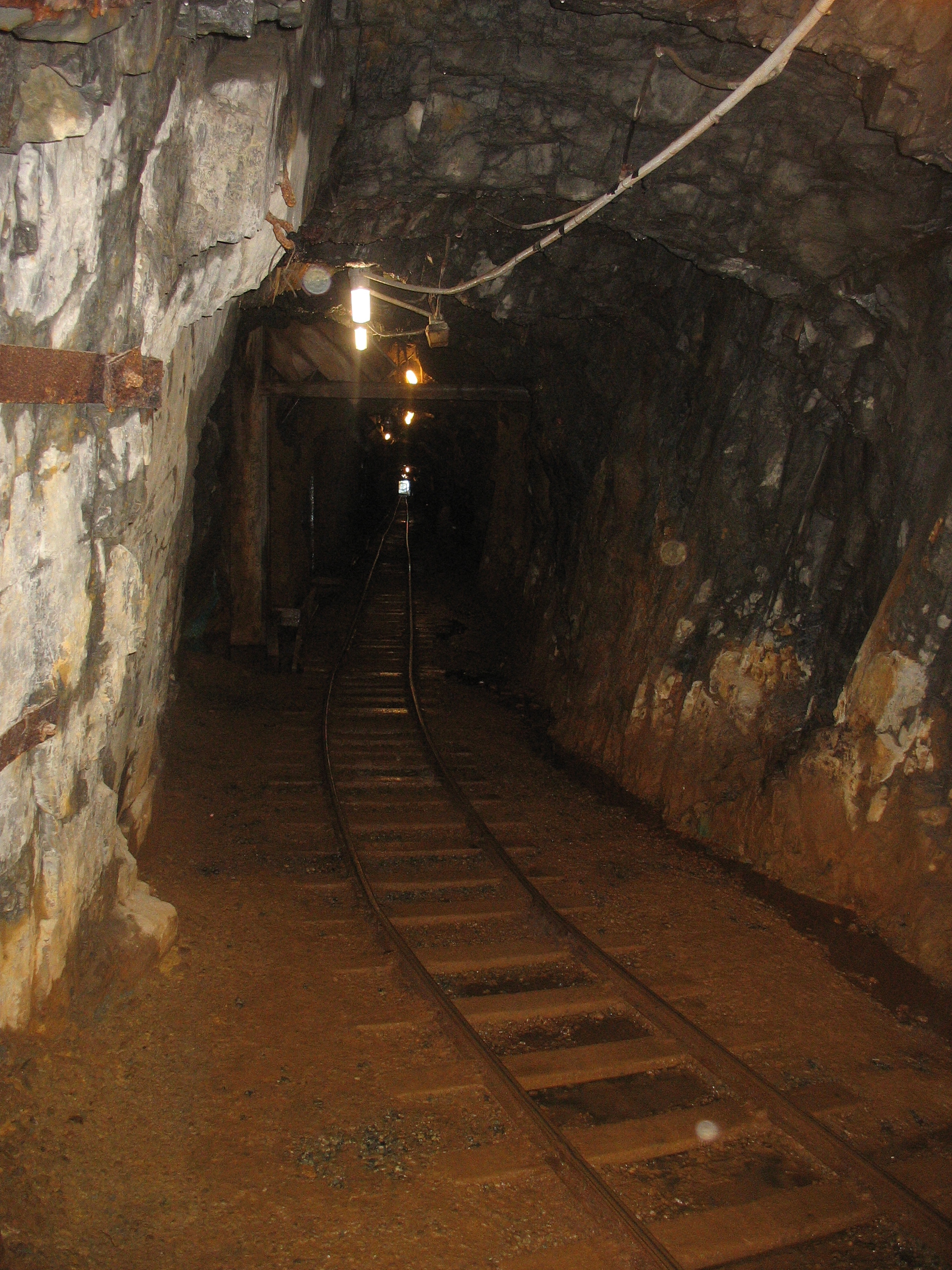
Billy Barker’s discovery of gold on Williams Creek in 1862 triggered a stampede of thousands of miners to the area. Travelling the Cariboo Waggon Road, their trip through steep canyons,  raging rivers and high mountain passes was a long and arduous one. Many of today’s highways follow that trail and along the way many remnants of their journey remain for today’s traveller to explore.

   credit

Searching for geocaches led us to many sites that we might otherwise have missed… Cemeteries like this one just outside the historic community of Yale where graves date back to the 1860s, some 40 years before the part of Canada that we call home was settled.

And churches like St. John the Divine Anglican, also in Yale, which was built in 1863 and is the oldest church in BC that still stands on its original foundation.

The early 1860s saw the construction of a series of roadhouses along the banks of the Fraser and Thompson rivers. Usually within a day’s ride of each other, these were places where weary travellers on their way to the gold fields further north could rest for the night, have a meal, and water and feed their horses. At historic Hat Creek Ranch between Cache Creek and Clinton, the location of one of these roadhouses, the buildings stand as they did in 1901 but some were built as early as 1860. We spent an afternoon there exploring the exhibits and even riding an old time stagecoach!

Next to Hat Creek Ranch is the very interesting Stucwtewsemc (Sluck-TOW-uhsen) Native Interpretation Site where we were able to see how the original occupants of the area lived. I have studied both the coastal and the plains natives quite extensively but I knew virtually nothing about these people who lived between the two. I found the kekuli lodge, or pithouse, particularly interesting. Built half underground and half above, a typical kekuli housed between 25 and 30 family members, from grandparents down to grandchildren, throughout the winter months.

With so much to see and do along the way, some days we didn’t travel very far at all. When we left a campground in the morning, we often had no idea what that day would hold or where we’d sleep that night. For example, one day we travelled only 112 km (70 miles) from Clinton to Lac La Hache Provincial Park but along the way we found six geocaches, hiked to the Mount Begbie fire lookout tower named after the swashbuckling chief justice who established law and order on the BC frontier during gold rush days, and played 18 holes of golf on the beautiful 108 Mile Resort course. I’d call that a productive day, wouldn’t you?

Now that we’re home and have internet access again, there’s much more to share including our visit to Barkerville itself but I’ll save that for future posts.
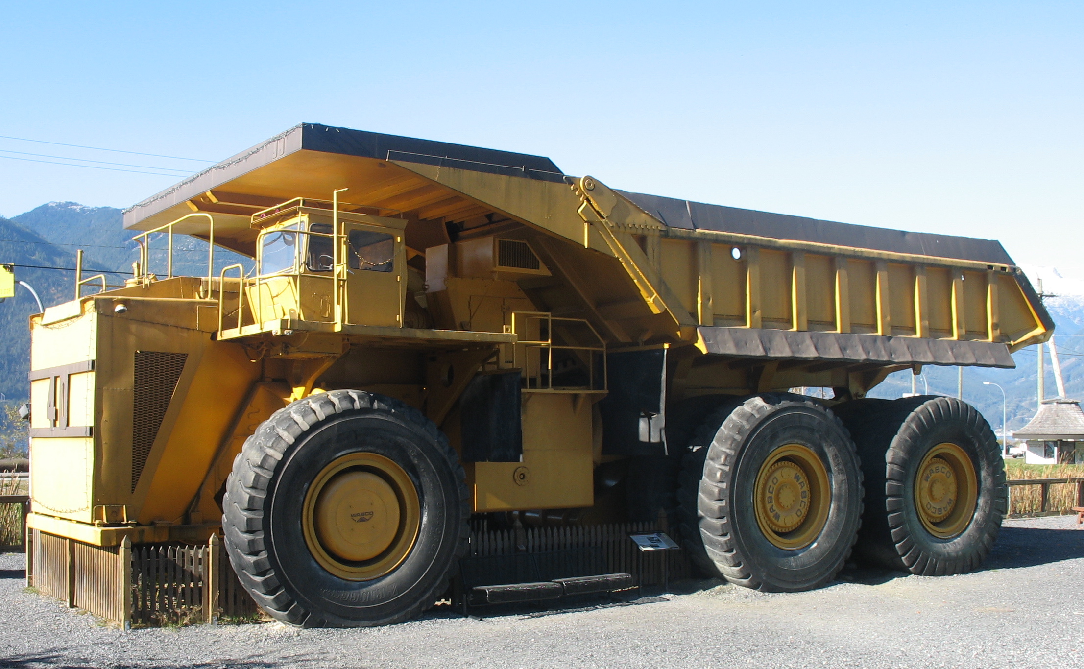
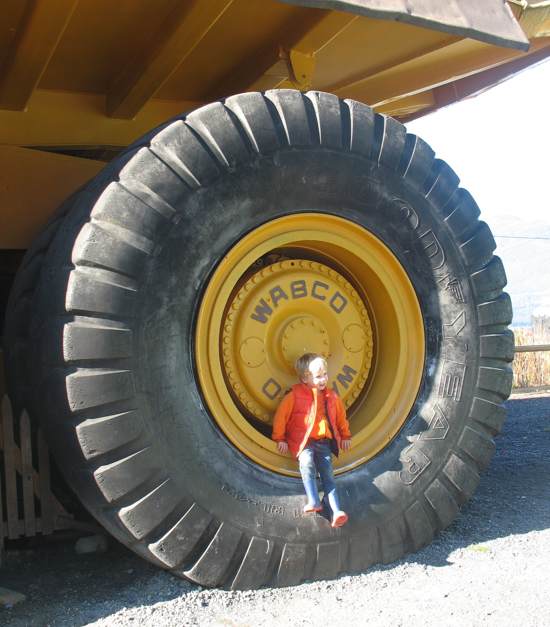
Cathedral Grove

Our recent drive to Port Alberni to spend a few days with Richard’s aunt and uncle involved passing through Cathedral Grove in Vancouver Island’s MacMillan Provincial Park. Though we’ve been there many times before, the towering stands of Douglas fir and Western red cedar never cease to amaze us. Trails on both sides of the highway allow visitors to stand in awe beneath these majestic giants, some more than 800 years old.

The park has changed since I walked its pathways as a child and since we wandered there with our own children some years back. On New Year’s Day 1997, a severe windstorm changed its look forever. Hundreds of huge trees were toppled and now lie amongst the undergrowth and some sections of the trail system were obliterated. Repairs to the trail system began immediately but fallen trees are part of nature. They open the canopy to provide light, space, shelter and nutrients for new growth. As gorgeous as the giant trees are, the lush growth on the forest floor is equally fascinating.

This year, geocaching added a new element to our visit to the park. Though there are several of them there, we decided to look for just two caches; one on each side of the highway. The dense canopy made it difficult for the GPS, which depends on satellite signals from high overhead, to give us accurate readings but hints given on the geocaching website helped us locate them. We had to be stealthy so as not to give away their locations to the many “muggles” (non geocachers) who were also enjoying the park.


I still love riding the ferries

The BC ferries were as much a part of my childhood as trick-or-treating at Halloween or opening gifts at Christmas. My birthplace, Powell River, wasn’t accessible by road until I was almost five. As the crow flies it’s less than 150 km north of Vancouver, but even today the trip takes about four and a half hours and involves two ferry rides. In the early days, the road across the peninsula between Earl’s Cove and Langdale was a narrow, winding one. Riding the ferries was a welcome break from carsickness and boredom brought on by the long drive.

Perhaps if I’d spent my entire life at the coast and continued to ride the ferries regularly, I might be as ho hum about it as many passengers are but for me, the ferry is still a thrill. I can’t simply hunker down with a book or my laptop as many passengers do. Regardless of the weather, I have to walk the outer decks and stand at the bow with the wind whipping through my hair. There are usually a few others who join me there.

It’s been several years since we last made the trip to Powell River but our time at the coast this summer did include riding ferries. I don’t think I’ve ever seen the ocean as calm as it was the day that we crossed over to Vancouver Island to spend a few days visiting relatives of Richard’s at Port Alberni and Nanaimo. Though Richard was one of the many who sat inside the entire way across, after we’d eaten lunch in the onboard restaurant on the return trip I did manage to get him to join me outside where he took a few photos of me reliving childhood memories and enjoying one of my favourite modes of travel.